Short answer: a cell tower locator app can give you a starting direction, but it cannot, on its own, tell you which cell tower to aim an antenna at. Most tower pins are estimates, not surveyed locations, and the app does not know your terrain, your mounting height or which tower actually carries a usable signal to your spot. To find which cell tower to aim antenna hardware at, treat the app as a list of candidates, then let your phone’s own dBm and quality readings pick the winner.
This guide explains where locator data comes from, why rural areas are where it is weakest, and a short method for checking an app’s answer before anyone climbs a ladder.
What a Tower Locator App Actually Shows You
Locator apps and websites draw on a few different kinds of data, and it helps to know which one you are looking at.
- Crowdsourced estimates. Phones running a mapping app record the cell they are connected to, the signal level and their GPS position. Software then calculates where the tower probably is. The pin is the output of that calculation.
- Structure registrations. The FCC maintains a public antenna-structure registration system. A registration record tells you a structure exists. It does not tell you which carriers have equipment on it, which way their antennas face, or whether it serves your address.
- The “connected tower” view. Some booster makers’ apps show the direction of the tower your phone is using right now, based on the cell it is connected to at the moment you check.
Each of those answers a different question. None of them answers the one you care about: which direction gives a donor antenna, at its real mounting height, the strongest clean signal on your carrier?
If you have not yet built a list of candidate towers at all, start with our guide on how to find the nearest cell tower to your home. This article picks up once the app has given you a pin, or several, and you are deciding whether to believe it.
Why the Pin Is an Estimate, Not a Location
CellMapper, one of the most widely used crowdsourced tower maps, is direct about this in its FAQ, which we read on September 27, 2026: “Tower locations are based purely on calculations.”
The same FAQ explains what makes those calculations accurate or inaccurate:
- For a tower to be placed properly, contributors need to travel “around the tower in at least 1/2 to 3/4 of a circle near the actual location.”
- “The most ideal terrain to calculate a towers is a completely flat ground with tower spaced wide apart.”
- Open water confuses the math: because water “usually doesn’t contain any object that can block signals,” the algorithm can average readings taken at very different distances and place a tower in the wrong spot.
- “LTE is the most accurately mapped technology due to using RSRP instead of RSSI.”
Wilson Amplifiers, a booster retailer, says the same thing in plainer words in its tower-finding guide, also read on September 27, 2026: “crowdsourced data isn’t always correct,” “Crowdsourced maps depend on how much data people have collected in each area,” and “tower and carrier data may not be complete in every area.”
Why Rural Properties Get the Least Reliable Pins
Read those conditions again with a rural property in mind, because they describe almost exactly the situation where locator data is thinnest.
- Few contributors. A crowdsourced map is only as good as the number of people who drove past with the app running. Rural roads see far fewer of them.
- Readings from one side only. A tower beside a single highway is often measured only from that highway. The FAQ’s half-to-three-quarter circle rarely happens when there is no road on the far side.
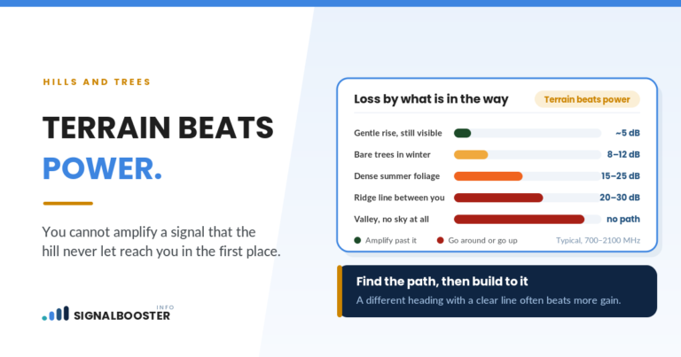
- Terrain. Hills and tree lines weaken signal in ways the algorithm can mistake for distance, which pulls the estimated pin away from the real structure.
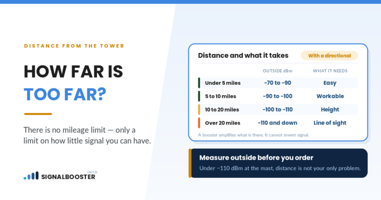
- Long distances. Wide spacing helps the math, but long distances mean a small error in the pin turns into a real error in direction.
So the areas where people most need a directional antenna aimed carefully are the same areas where the pin is most likely to be off.
How Much a Wrong Pin Changes Your Aim
This is simple geometry, and it is worth doing once. The angle you are off by is roughly the pin error divided by the distance, converted to degrees.
| Pin error | Distance to tower | Approximate aiming error |
|---|---|---|
| 0.25 mile | 2 miles | About 7 degrees |
| 0.5 mile | 5 miles | About 6 degrees |
| 1 mile | 10 miles | About 6 degrees |
| 1 mile | 3 miles | About 18 degrees |
These are arithmetic, not measurements of any app. The point they make is practical. A narrow-beam directional antenna rewards precise aim, so a pin that is “close enough” on a map can still leave the antenna pointed slightly off the strongest path. More importantly, even a perfectly placed pin only tells you where the structure is. It says nothing about whether a ridge sits between you and it.
The Nearest Tower Is Not Always the One to Aim At
A locator app naturally draws your eye to the closest pin. For aiming, closest is only one factor. A farther tower can be the better target when:
- The nearer one is blocked by a hill, a timbered ridge or a large building, while the farther one has a clearer path.
- The nearer one is not your carrier’s. A structure on the map may not carry your carrier at all.
- The nearer one is busy. A strong reading with poor quality can point to a loaded or interfered cell, which amplification will not fix.
Our walkthrough on choosing which rural tower to aim at covers that comparison in detail, including how terrain changes the answer.
Find Which Cell Tower to Aim Antenna Toward: A Five-Step Check
You can test an app’s answer from the ground with nothing more than your phone. Turn Wi-Fi off first so the phone stays on cellular. Our guide on checking your phone’s real signal strength in dBm shows where to find RSRP and a quality figure such as SINR or RSRQ.
- List candidates, not a winner. Note every pin on your carrier within a reasonable range, with the compass bearing from your property to each one.
- Filter by carrier. Drop any pin that is not listed for your carrier. A tower you cannot use is not a target.
- Walk the property with the readings on. At several outdoor spots, face each candidate bearing in turn and hold the phone still for a minute. Write down the typical RSRP and quality value, not the best flash.
- Compare direction, not just strength. If readings are consistently better facing one bearing, that is evidence. If they are best facing a direction with no pin at all, trust the readings: the tower may be missing from the map or placed in the wrong spot.
- Record your results. A written list of bearings and readings is exactly what an installer needs, and it is what you will compare against after the antenna goes up.
Expect the numbers to wander. Readings shift as the phone moves between cells and as network load changes, and different apps report values differently. The explainer on why signal apps give inconsistent readings covers how to keep your measurements comparable.
What Ground Readings Cannot Tell You
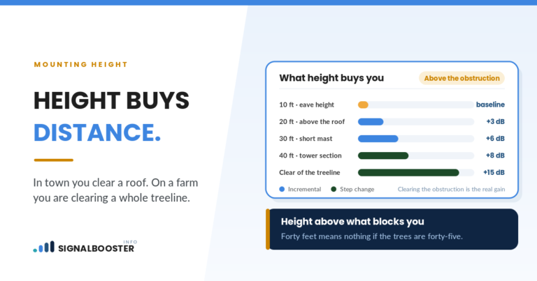
Your phone at chest height is not the same as a donor antenna on a mast or roofline. Height often opens up a path that ground level cannot see, especially over a tree line. So a ground walk is a strong filter, not a final answer.
The final check happens at the antenna’s actual position, with the antenna turned slowly across the candidate bearings while someone on the ground watches the reading. That is roof or mast work. Anything involving a roof, a tall ladder or a mast belongs to a qualified installer, and any new outlet or wiring belongs to a licensed electrician. Your written list of candidate bearings and ground readings makes that job faster and less of a guess.
When the App Is Most and Least Useful
Most useful:
- Flat, open country with several well-mapped towers on your carrier.
- LTE service, which the CellMapper FAQ says is the most accurately mapped technology.
- Towers along well-traveled roads that people have driven around.
Least useful:
- Hilly or heavily wooded land.
- Towers reachable only from a single road.
- Remote areas with few pins at all, where the one tower that matters may not appear.
In the second group, treat the map as a rough hint and let the bearing walk decide.
FAQ
Are cell tower locator apps accurate?
They vary. Crowdsourced maps calculate tower positions from users’ readings, and CellMapper’s own FAQ says its locations “are based purely on calculations.” Accuracy is best where many people have taken readings from all sides of a tower on flat ground, and worst in thinly traveled, hilly areas.
Should I aim my antenna at the nearest tower?
Not automatically. The nearest tower may be blocked by terrain, may not carry your carrier, or may be heavily loaded. Compare the candidates with your phone’s dBm and quality readings and aim toward the direction that measures best.
Why does my signal seem strongest in a direction with no tower on the map?
Either the tower is missing from the map, or its pin is in the wrong place, or the signal is reaching you along a clearer path. Trust repeated readings over the map.
Can I aim a directional antenna from the ground?
You can do most of the planning from the ground by walking the property with your phone’s readings on. The final aim has to be checked at the antenna’s real mounting position, and roof or mast work should be left to a qualified installer.
Does a carrier coverage map show where towers are?
No. Wilson Amplifiers’ tower guide notes that “carrier coverage maps will not help you find nearby cell towers.” Coverage maps model service areas. They do not mark structures.